The Flood Barrier
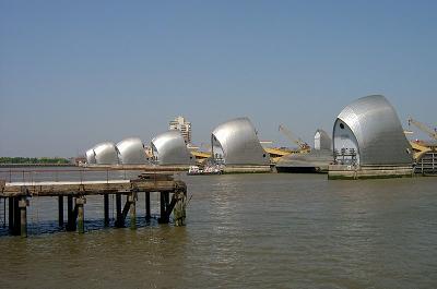
From a distance it looks like a line of “hoodies” crossing the river. As I get closer the stainless steel hoods of one of the engineering marvels of the world become clearer. There in front of me is the end of my journey, the Thames Flood Barrier.
 The Flood Barrier
The dangers of a serious flood to London can not be overstated. The workings of the capital would come to a complete stop and take many months to get going again. Adverse weather combined with certain tidal conditions would cause a tidal surge in the North Sea that would be magnified by the Thames Estuary and force a wall of water into the city. To prevent this potential devastation the Greater London Council commissioned the Flood Barrier.
Work started in 1974 and the barrier was officially opened on May 8th 1984. The defences have had to be used more than a hundred times since then to protect against possible flooding. The gates only need to be closed for high tide to stop the upward surge. When the tide is ebbing the gates can be opened to allow the flows from the upper reaches to enter the sea.
The barrier is a formidable piece of engineering, stretching for 572 yards from bank to bank. The steel cowls cover the lifting mechanisms and divide the river into manageable sections. Between each of the towers are the gates. When open the gates lie in concrete dishes parallel to the river bed, and are pivoted into an upright position when required to fulfil their purpose. The four largest gates are 61m wide and 20m high, each one weighing 3,500 tonnes. The two smaller navigation gates are 31m wide, and at each of the ends are two radial gates completing the bank to bank barrier.
Testing takes place every month, when the gates are raised into position. The dates are published on the Environment Agency website.
< Previous Page | Reflections >